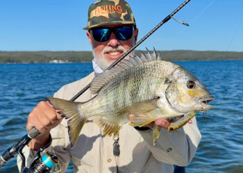
There’s a lot of information available on sea surface charts that can help you find fish.
THERE’S been plenty written and spoken on the subject of sea surface temperatures and its effect on gamefish. However, I’m surprised how much more there is to learn from these satellite imaging services. I hope within this article we can bring a few of the more advanced features to your attention. Start including these each time you check the SSTs and I guarantee your success rates will improve.
There are a couple of options for accessing SSTs. The well-known services are Rip Charts and FishTrack. Both these services come out of the USA, however they do a great job of catering for the Australian market. Both are a paid online subscription service and each has a mobile application available for people to access the service through. There’s also some free online web based stuff, such as on the CSIRO SST site. The CSIRO site’s data is 24 hours old, so if you are only looking for historical info then these probably work ok, albeit very limited in the data you can extract from them. Let’s be honest here, we are all looking for an edge over the other boats; the more recent the information we can access, the better our chances are of finding fish. There is one other service I know about, another paid service, that’s more of a commercial site and certainly more expensive than the prior mentioned. However, it provides its users a “fish prediction” service, where users have likely co-ordinates emailed to them. Pretty handy for those who can afford the service. I’m most familiar with RipCharts so my article will be mostly related to the features included within that package.
We all know that pelagic fish travel past our coasts in currents. Along the east coast of Australia this is called the East Australia Current (EAC). With the arrival of this around December each year anglers across NSW start to ramp up their efforts in search of the first marlin of the new season. This current is a warm tropical current. As it makes its way down the coast, usually along the continental shelf, it passes over known fishing aggregating areas such as canyons, kinks, drop-offs, etc. These sudden changes in depth create turbulence in the EAC and as a result the ecosystem tends to become more prevalent over those areas. At the same time, areas of the EAC can break away or be held up. These are most usually noticed in the form of temperature breaks where colder water meets warmer water. In these areas again nutrient rich water attracts small bait fish, and in turn large target species like marlin find the bait. For some time this was all we looked for, and had good success working temp breaks alone. However, as technology improved along with the ability for scientists to analyse satellite imagery against catch rates, we started to find other key indicators to pay attention to when chasing pelagic fish.
Sure, water temp breaks are important, however so is water colour, clarity, current strength and direction and sea surface heights (altimetry). If we can align a few more of these things up around a temp break at the right time of year, you can turn a fishless day into your best day’s fishing.
Pelagic fish rather prefer the areas where the current is slower.
Currents
We usually head out and expect to find current. The old saying goes, “no run, no fun”. Generally, fishing is good if there is some current, however, sometimes too much current can be detrimental to fishing. Fish are like us, pretty lazy; if they don’t need to swim into current they won’t. Bait doesn’t build well in areas of strong current, and if it does, it moves damn quickly. Pelagic fish rather prefer the areas where the current is slower, the same areas bait tends to stack up. It’s my experience that current pushing in from the west is the most productive for gamefish. This tends to push bait fish out of the main EAC and if that ends up over the top of known productive areas, you won’t have to look far to find your target species. This is a good place to start your search. I would certainly concentrate my efforts in areas with west current over east or purely downhill. I find the info provided over these SST services more reliable offshore than over the inshore reefs. The currents inshore are more fickle and quicker to roll over or change. This can happen within hours, around tide changes, or overnight. This is where swapping notes between your mates can give you an edge.
Sea surface heights (Altimetry)
Now this is a big one and possibly one of the more misunderstood tools available to fishos. Right up and down our coast we have what’s known as “up and down wellings” occurring. Within these areas the physical height of the water is either higher in a down welling or lower in areas of an up-welling – confusing, hey! Imagine if we were able to look perfectly over the surface of the ocean, these areas would be like small contour changes, like small areas of watery hills. Within these up/down wellings there is a vortex effect taking place, with water eddying in either a clockwise or counter clockwise direction. Thinking back to the point before where we talked about current direction picking an up-welling that has a westerly current pushing in, aligned with a temp break, your chances are getting even better. The actual sea surface heights are shown as numbers on our charts. An example can be seen within an image within this article. Here we can see readings of -20, -10, 0, +10 and +20. It’s the areas showing the zero we are looking for. Consider any water running along a zero altimetry the “fish freeway”. This is the area of least resistance for the fish to hang out. Water a mile or so either side of the zero line usually looks the fishiest and generally produces better than others.
Water colour
This can be a debatable topic. Do fish prefer clean clear water? Is it our own psyche that tells us to fish the clear clean water? My experience shows that there are arguments for both. One thing I’ve learnt is there are no fences in the ocean, meaning sometimes the rules don’t apply. If I head out looking for clean clear water and only find good amounts of bait in the dirty side and no bait in the clean side, I will put my effort into the water with the bait. At the end of the day, the simple thing is, fish feed on bait, not clear water.
Too many people can’t get past that fact and burn too much time enjoying fishing clean water in the hope they run a fish over, where the guys that disregard the water colour actually catch fish, because they worked the bait. The satellite imagery provided by Rip Charts shows what’s known as “true colour”. This is basically a photo taken from space of the water surface. It is amazing how clearly you can see the areas of colour change. Message here is, don’t just fish clear clean water. This season a winning fish we caught during a tournament came from some of the worst water I have fished in. This water was both cold and green. We were pulling slime off our leaders each time we checked baits. That particular day tested my will to fish dirty water, however, I was on decent bait and my electronics showed me that there were marlin in the area. It was just a matter of time before the bite would come, which it did, resulting in our largest pay day whilst fishing tournaments.
Chlorophyl
Chlorophyll is another really important element to consider and observe. These charts basically show where the ocean’s “plants” are growing. Phytoplankton basically contains chlorophyll which absorbs sunlight and essentially turns into fish food. Where large concentrations of chlorophyll exists you usually find the beginning of the fishing ecosystem. The Chlorophyll charts will usually have a close relationship to the areas of water colour changes. Something to be mindful of here is how these charts can be affected after heavy or flooding rain. The run-off from these events will pump nutrient rich water into the ocean through the many inlets and estuaries along our coast line. These areas, usually seen close to shore can look promising, however almost always turn out to be dirty, cold run-off water devoid of life.
Temperature
So if we can now combine a few of the previously mentioned elements into a concentrated area and find a nice change in temperature (commonly called a temp break) we are in good shape. Even the subtlest change of say half a degree or sometimes less can be enough to spur things on. Keep a close eye on your water temperature gauge on your sounder. If you don’t have one (most are built into the depth transducer) do yourself a favour and invest in one. It’s fine to check your SSTs before leaving or even have them with you out on the water, however, if you can’t cross reference them with what is under your boat in real time then you will struggle to put yourself in the right area.
Ultimately even with access to all the technology available to us, at the end of the day it’s important to not lose sight of one of the best tools we have to find fish, this being our eyes. Your eyes will show you signs both above and below the water that indicate you are in the right area. Don’t forget to not over complicate your day, and trust your instincts!