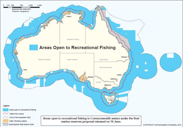
THE extent of fishing bans that will come into affect under the federal Government’s proposed network of marine reserves has been revealed. Fisho has today received a map from Environment Minister Tony Burke’s office which basically sets out to placate Australia’s anglers via the highlighting (in blue) of the amount of coastline still open to recreational fishing.
Admittedly, at first glance the size of this blue zone looks substantial but once Fisho delved deeper into the detail, the extent of proposed closures, especially those in the Coral Sea and the south-west of WA, were revealed. This beggers the question, why?
The Government has this week defended its decision to close much of the Perth Canyon to fishing – an area off the coast of Fremantle popular with WA fishos – because the region is visited by pygmy blue whales. Fair enough, perhaps, but how exactly does recreational fishing directly affect the migratory habits of these creatures?
Surely in the case of the proposed Coral Sea closures, revealed as a gaping chunk of grey on the map, it appears the federal Government has bowed to the requests of green groups and closed off such a substantial zone without any scientific justification. And yet, green groups are still not happy and have come out this week to push for more closures…
Surely a better compromise can be reached, especially in relation to the south-west WA and Coral Sea zones? What do Fisho readers think? View the map here.
The federal Government has also released a list outlining the distances (in kilometres) many cities and towns are from the nearest proposed marine reserves. This list does not, however, take into account the pre-existing marine parks in many states that are situated a lot closer to the coast and to many of the towns/cities that are listed.